Saturday, January 26, 2019

Friday 02/01/2019 Miner’s Needle/Coffee Flats

This hike was canceled due to rain at the trailhead. Some hikers went to Casa Grande Mountain for a short hike.


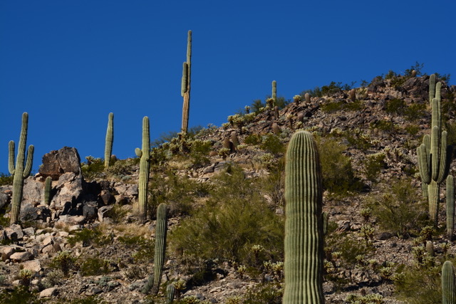
Directions: Go north on Highway 79 out of Florence. Go left (west) on Highway 60 at the Florence Junction. About 8 miles from the junction, turn right at traffic light on East Peralta Road proceed through the residential area and past the school and onto a gravel road to Peralta Trailhead (about 7 miles). Pit toilets.

Google Maps to Peralta Trailhead

Coffee Flat Trail - All Trails


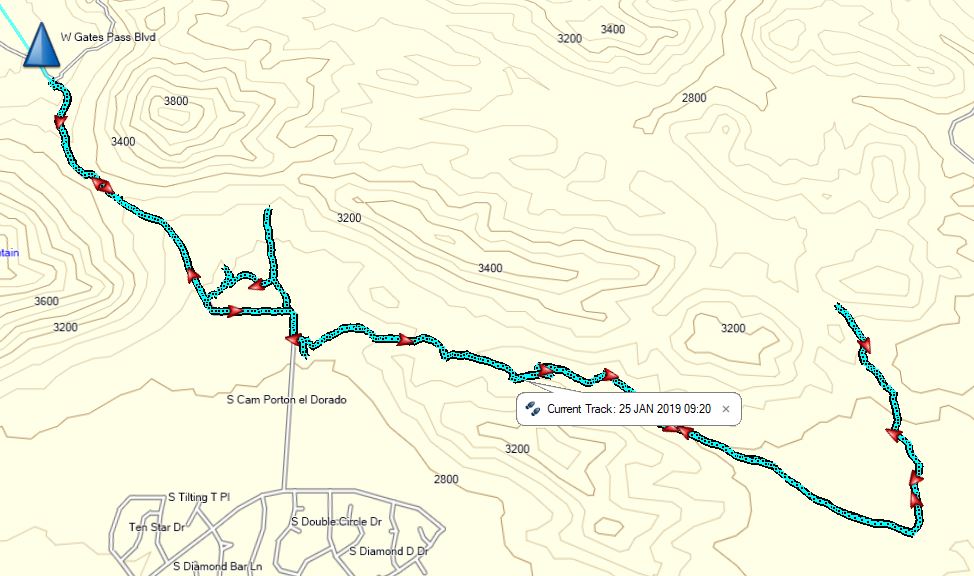
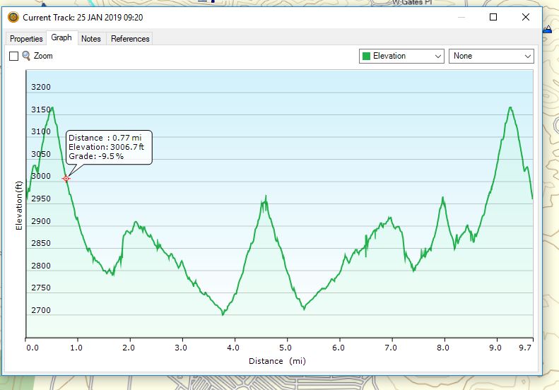
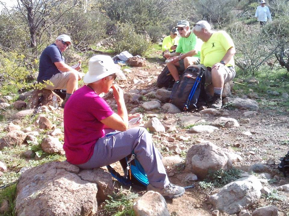
This hike is about 6.5 miles - Out and back hike.


Upcoming hikes
Friday 02/08/2019
Garwood Loop
Friday 02/15/2019
Fat Man’s Pass
Friday 22/08/2019
King’s Canyon Hugh Norris
  Skip’s cell: 503-580-3828     Barry’s Cell: 207-205-4298


Monday, January 21, 2019

January 25, 2019 David Yetman Hike

This is a fairly easy hike through desert landscapes, between hills and over saddles with a good mix of vegetation and some scenic views. There are some large areas of Saguaro Cactus on the way and some good stands of Cholla as well. A Double Crested Saguaro was sighted just off the trail.


Mikes Group


Need to turn left at this caron. There is no sign. (other trail goes toward development)


Double Crested Saguaro


Barry's Hike


Skip's Hike - Casa Grande Mountain


Directions: From Florence Blvd turn onto I-10 East and take exit 257 and turn right onto Speedway Blvd. Keep going as the road name changes to Gates Pass Road. Proceed over Gates pass to the bottom of the hill and turn left into the parking area. It is 60 miles.

Google Maps to David Yetman Trail

All Trails Map for David Yetman Trail

Yetman was born in New Jersey. His father was a minister for the Methodist Church. Following the onset of acute asthma, his family moved him to a dry climate of southern Arizona when he was a teenager. They arrived in Duncan, Arizona in 1954 and then moved to Prescott in 1955 where he went to high school.
Remaining in Southern Arizona, in 1970 he began trading carvings made by the Seri Indians of Sonora, Mexico and began to investigate their livelihoods and culture. He also worked in the Chiricahua Mountains. He completed a PhD in Philosophy (University of Arizona, 1972). In 1977 he ran for political office and was elected to the Pima County Board of Supervisors as a Democrat, serving until 1988. He used his role to preserve public lands in and around Tucson. He then worked as Executive Director of the Tucson Audubon Society, and then from 1992, joined the University of Arizona's Southwest Center as Research Social Scientist.

Thursday, January 17, 2019

Jan 18, 2019 Picketpost South


Barry's Group 


Longer Hike 


Directions to Picketpost Trailhead

Go right (north) out of Palm Creek for 0.7 miles, then go east on Cottonwood Lane 2.8 miles to Overfield Road. Turn north and travel 3.4 miles to SR 87. Turn east and go 7.8 miles to Attaway Road (2nd traffic light). Go north 2.9 miles to Hunt Highway. Turn east and go 6 miles to SR 79. Turn north and go 12.7 miles to the junction with Hwy 60.  Go right on Highway 60 toward Superior for  9 miles to milepost 221.5 and turn right at the brown Picketpost Trailhead sign onto FS Road 231.  Drive 0.4 miles and then turn left at the brown sign onto FS Road 310. Proceed for 0.6 miles into the parking area.
Coordinates: 33°16’21.63”N   111°10’37.21”W

Facilities:  Pit toilets, ample parking.


Google Maps to Picketpost Trailhead


Picketpost Mountain is named after a military encampment at the base of the mountain in 1870. This was a time of the Apache wars and General Stoneman was the head of the camp.
THE GEOLOGY OF PICKETPOST MOUNTAIN, PINAL COUNTY, ARIZONA by Eleanor W. Nelson A Thesis Submitted to the Faculty of the DEPARTMENT OF GEOLOGY In Partial Fulfillment of the Requirements For the Degree of MASTER OF SCIENCE In the Graduate College THE UNIVERSITY OF ARIZONA 1 9 6 6.