 |
Jerry's group for Medium Hike - Buena Vista parking lot |


 |
| Dobbin's Lookout |
The Medium Hike starts at Summit Road for a 7.5 mile hike Hidden Valley, commonly known as Fat
Man’s Pass. This hike is fun, hiking over and under great boulders.
The Long Hike also goes to Hidden Valley, but it takes hiking trails up a ridge that overlooks the
Airport and the City of Phoenix. The rock formations are unique to the area.
Airport and the City of Phoenix. The rock formations are unique to the area.
Directions:
Summit Road - Medium Hike - Take 1-10 north to exit 155 (33 miles). In 0.9 miles turn left on
Baseline Road. Follow Baseline for 4.7 miles then turn left onto S. 7th St. In one mile turn right
onto East Dobbins Road for 0.4 miles Then turn left onto S. Central Ave. and drive for 1 mile.
There is a Ranger Station and Washroom facilities here. Proceed on S. Central Ave for another
1.6 miles and wind up the road, turn left onto Summit Road and wind further for 3.7 miles to Dobbins
Lookout to the parking area. There are also washroom facilities at the Dobbin's Lookout.
51 miles driving distance.
Pima Canyon Trailhead - Long Hike - Take 1-10 North for 31 miles to exit 157 to Elliott Road.
Turn Left on Elliott Road for 1.1 miles then turn right onto S. 48th St. keep following S. 48 St.
as it turns left at a left-hand turn lane.
Turn Left on Elliott Road for 1.1 miles then turn right onto S. 48th St. keep following S. 48 St.
as it turns left at a left-hand turn lane.
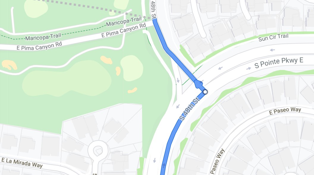
(If you do not turn left and follow what looks like 48th street to the right you will end up on
St. Point Parkway E.- don’t go here. If you miss this turn and are on St. Point Parkway -
keep following it until you see 48th st. where you can turn left and loop back on 48th and
to the Pima Canyon Trailhead.) Then turn an immediate left to Pima Canyon Road.
Follow this road to the trailhead. There are pit toilets and a large parking area. 42 miles
driving distance. B- hike. 7 - 8 miles.
Casa Grande Mountain Hike
Casa Grande Mountain Hike leaves the Palm Creek Parking Lot at 8:00 and arrives back to the
Park before lunch.
Park before lunch.
Proposed next hikes- Schedule may change
February 7 - Hutch’s Pool - Sabino Canyon - Out and back - There is a tram ride and fee.
February 14 - Medium Hike - Miner’s Needle out and back
Long Hike - Coffee Flat - Out and Back
February 21 - Picketpost Mountain - South Trail - Medium Group.
Picketpost Mountain - Long hike - Picketpost Mountain Loop - Counterclockwise
Nancy’s cell: 403-896-9899
Note: These hikes are designed to be an outing, not a race. Hikers are encouraged to hike
together, socialize, and enjoy the fresh air and exercise, stopping as necessary to rest. To
assure all hikers are accounted for, drivers will make sure that all the same hikers they take
return with them.
together, socialize, and enjoy the fresh air and exercise, stopping as necessary to rest. To
assure all hikers are accounted for, drivers will make sure that all the same hikers they take
return with them.


