Showing posts with label 2018. Show all posts

Thursday, January 6, 2022

January 7, 2022 - American Flag Ranch Trail


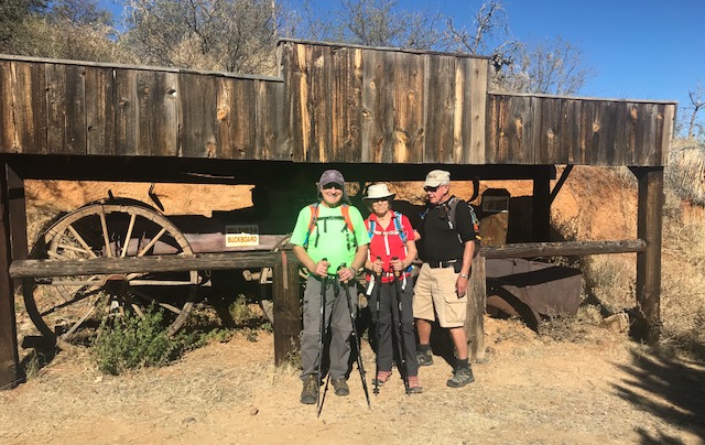
This is a very scenic hike from a roadway just east of Oracle to the Oracle Ridge Trail where we look down on the Biosphere and have fantastic views of Picacho and Table Top. It is also part of the Arizona Trail. The flora and geology in the area are quite different than our normal hikes and the elevation is higher, from 4,400 feet to 5,400 feet. We will stop at the Hi-Jinks mine where Buffalo Bill Cody mined for gold and view the old 1895 Bain 9-A buckboard that was used in the filming of Poker Alice starring Elizabeth Taylor. This is an out and back hike for a total of 7.4 miles and rated as a B-. Hiking time will take approximately 3 hours and 45 minutes. Our return time to Palm Creek is about 7 hours. There is ample parking, however, there are no pit toilets but plenty of bushes.

Directions:

(GPS: Hi-Jinks Ranch)  Take I-10 east to exit 219 for Picacho Peak Rd, turn left to Camino Adelante. Travel 5.1miles and turn left onto E Park Link Dr. After 18 miles, turn right onto AZ 79S and proceed 10 miles to AZ 77 N. Travel south 9 miles and then turn right onto W American Ave. (Signs for Oracle). About 2 miles turn right onto E Mt Lemmon Hwy. and continue 5 miles to Campo Bonito and turn right again on S Highjinks Rd. Trailhead is ahead about a half-mile.

Short Hike:   

Short Hike around the trails on Casa Grande Mt. led by Reno and Denis. Their hike averages 3-4 miles and they are usually back to Palm Creek by noon. This hike will leave from the central mailboxes at 8:00 a.m. this Friday and hikers must have a Palm Creek Hiking Club Waiver. Try to be sure to be at the mailboxes by 7:45 a.m. to secure waivers.

January Hikes 

January 14th, Long Hike, Fat Man's Pass from Dobbin Lookout, out and back. Medium Hike, Fat Man's Pass from Overlook, out and back.

January 21th, Dynamite Trail at San Tan. Medium hike!

January 28th King's Canyon. We will try and see if we can do both a long and medium hike!

Remember:  If for some reason a hike must be cancelled, you will receive an email by 6.a.m., Friday morning!

Thursday, February 11, 2021

Hidden Canyon, Bowen and Yetman Trails - February 12, 2021

This is an easy to moderate hike, approximately 6 miles, through typical vegetation of the Sonoran Desert. There are only a few areas with slight elevation gain. The hike forms two loops or a figure-eight by starting at one trailhead where we park and ending at another only a couple blocks away. About halfway through the hike, we visit the Bowen homestead, a house build of native stone but at one time suffered fire damage. Although there is no roof, the sturdy walls and fireplaces remain. No Pit Toilets but plenty of bushes. 

All Trails - Hidden Canyon Loop - Bowen Stonehouse Ruins via Yetman Trail


Hidden Canyon 


Directions: Palm Creek to Florence Blv. and to I-10E for Tucson. Continue on I-10 for 64 miles to exit 259, Starr Pass Blvd. Use the right lane to merge onto Freeway and W. Starr Pass Blvd. There will be a Waffle House on the left. Continue 4.2 miles to the end of the road where there is a huge Marriott Hotel at Starr Pass. (Good GPS address, 3800 W. Starr Pass) 

Don't forget our Friday Morning short hike around Casa Grande Mountain led by Reno and Denis. This hike averages about 3 miles and hikers are usually back by noon. The group will leave from the mailboxes at the same time as the regular hike (8 am) and must have a Palm Creek Hiking Club Membership Waiver signed. 

Remember if for some reason a hike must be cancelled, we will email you by 6 am on Friday. 

Upcoming hikes:

Feb 19, 2021

The Gold Mine Trail at San Tan. Approximately 7.2 miles. (Loop). Rated moderate. Parking fee $7.00 per vehicle. (Neat Trailhead with restrooms, plenty of parking and outside attractions to view)

February 26, 2021 

Picketpost. (Clockwise loop) Approximately 8.5 miles. Rated moderate. Pretty much flat but a longer hike. (Pit Toilets) 

Jerry's Cell 307-630-0252

John's Cell 207-446-0650


Friday, December 28, 2018

Friday Dec. 28th, 2018 Pima Canyon (Medium and Long Hikes) Short Hike to Casa Grande Mountain

Pima Canyon is one of the gems of the front range of the Santa Catalina mountains. The canyon has been occupied by humans since long before a European ever set foot in the New World, as evidenced by the mortar holes ground into the bedrock in the canyon which has been added to around 750AD. The holes were left by the Hohokam, and the canon is named for one of their presumed descendant groups, The Akimel O'odham (formerly the Pima).


Barry's Group


Mike's Group


Directions to Pima Canyon - East Magee Road
Take I-10 East to Exit 246. Turn left on W Cortaro Farms Road. In 3.9 miles Cortaro Farms Road becomes W Magee Road. Continue east an additional 3.9 miles to the end of the road. (W Magee Road eventually turns into E Magee Road after crossing highway 77). The parking lot is on the right. Total 61.3 miles drive from Casa Grande.

Google Map Link
Pima Canyon Trailhead


"All Trails" Link to Pima Canyon Trail.
The link to All Trails shows many trails in a certain area. It is not necessarily the one this group will go on.