Sunday, March 15, 2020

Year End Meeting

Covid 19 restrictions put a damper on the annual year-end party at Palm Creek. The leaders
had a spur of the moment, small meeting outside Skip and Connie's to present them with
a plaque for their long service to the hiking club. As luck would have it, it poured rain just as
we got there.
Connie invited us in and we sat on chairs spaced far apart. Our first experience with social
distancing.
When we posed for the pictures with our certificates for milage I am afraid we got a little too
close. It was lucky that there was no Covid in the Park at that time.
It was a special time for the leaders, but we were sad that the whole club membership
could not be there.


In Appreciation to
Skip and Connie Emerson 
for 18 years of service as Hiking Club Coordinators
- Leading and Scouting Hikes
- Promoting the Hiking Club
- Memberships, emails and milage
- Organization of: Grande Canyon Hikes,
Weekend hikes in Sedona and Chiricahua's and 
 Year-End Parties 
-Initiating Assessment hikes and safety measures
-Casa Grande Friday Hikes
Hi De Ho - We are off to hike!


March 20, 2020 Pichacho Peak - Changes

The Sunset Vista Trail at Picacho Peak is spectacular with spring flowers and views of surrounding mountains.   
All three groups will be hiking there this week. 
There is a fee of $7.00/car up to four people. If there are more than four, they charge an extra $3.00.
We will all meet as usual at the parking lot and leave by 8:00, but we will not be organizing carpools. Please organize your own ride.  


Sunday, March 8, 2020

March 13, 14, and 15, 2020 Chiricahua Hike and Casa Grande Mountain

March 13, 2020, Group Picture of Hikers - Chiricahua Group and Friday Hikers


March 13 - Natural Bridge - 5.1 miles. Both groups hiked into this beautiful area surrounded by pinnacles. There is still a presence of the forest fire that swept through the area several years ago. There are pine trees and other vegetation growing in high and low areas of the hike. We crossed three streams along the way. The Natural Bridge can be viewed across a gorge where we could see that it has been eroded by water coming from the top of the rock face. Pictures from Jerry. Jerry and John were leaders of small groups. 
Jerry's Pictures 


Nancy's Pictures 
There was a stream at the beginning of the hike


March 13, 2020 Linda and Kevin went to Fort Bowie. Fort Bowie, National Historic Site. 


March 14, 2020 - Chiricahua National Monument Trails


Both groups at the top of Massai Point
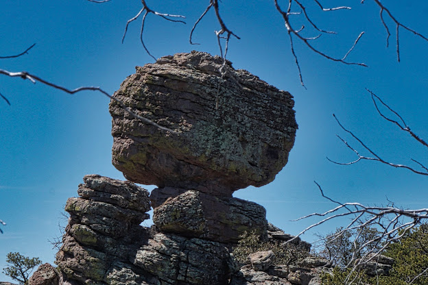
The medium hikers went down Ed Riggs Trail as planned. This trail met Mushroom  RockTrail which had plenty of elevation. Then on to Inspiration Point for Lunch. A beautiful viewpoint of the pinnacles and surrounding area. From there it was time to play in and around the rocks on Big Balanced Rock Trail and the Heart of the Rocks. Many of the rocks are named for the shapes they look like (Punch and Judy, the Kissing Rock). From here the trail goes down the Sarah Demming Trail down many steps along a ridge. Then onto a more gentle trail, the Lower Rhyolite trail and back to the trailhead. 
Jerry was the leader of this 8.7 mile hike. 

Jerry's Pictures


The Long Hike started at Echo Canyon Trail to the Grotto where water had made cavelike structures. The Hailstone trail goes along a ridge and goes back to Mushroom Rock Trail. Otherwise, the trail is the same as the Medium group. The long group and medium group met as the Medium hikers were coming from lunch and Inspiration Point and again as they were coming out of the Heart of the Rocks. John lead this 10.7-mile hike. 

Nancy's Pictures


March 15, 2020, Sugarloaf Trail at Chiricahua's 
This hike is a short 1.9 mile hike up to a Forest Ranger Lookout. It is 7258 feet elevation. It has great views of where we hiked the day before. We could see Sara Demming Trail, part of the Lower Rhyolite trail and all three parking areas. 

Nancy's Pictures


A map of all the trails we hiked. We can see the proximity one is from the other. 


Things to do before the hike. 
Prepare and bring your lunch because we will eat on the trail for Friday hike. We can get sandwiches etc at Safeway on Friday night for the next hike. It is within walking distance from the Sure Stay Best Western. There are fridges in the rooms for beverages and lunch for Saturday and Sunday Hikes. It is supposed to be cool weather so dress in layers. Bring water.   

Friday - We will meet at the Mailboxes as usual and sign in for the hikes. If you have not secured a ride please email me. Leave the park at 8:00 a.m. The group hikes (see next page) are both out and back. After the hike, we will travel back to Willcox and check into the Sure Stay Best Western. Dinner is on your own. You may want to check out the restaurants prior to arriving. Restaurants in Wilcox. There several Mexican restaurants, family restaurants and there is the Big Tex BBQ that is located in a railroad car. 
*Remember to purchase sandwiches and snacks at Safeway for Saturday’s hike if you didn’t bring food from home.
Saturday - Hot breakfast in the Sure Stay Best Western. In order to get a timely start to the hike, drivers can line-up cars outside the hotel at 7:45. We will travel to the Chiricahua National Monument Visitor Center. We will take most cars to the top of the Bonita Canyon Drive to Massai Point where there is parking. There will be a car left below in order to take drivers to the top after the hike to get their cars. There will be a long and medium hike (see next page). Drive back to Wilcox and dinner will be on our own again. *Remember to purchase lunch for tomorrow’s hike.
Sunday - Hot breakfast in the Sure Stay Best Western. Same protocol for cars when leaving the hotel. All cars will go to the top of Bonita Canyon Drive to Massai Point Parking lot because this hike is an out and back (see next page). After this hike, we will travel back to Casa Grande.

Directions: Drivers - Please review Google Maps prior to leaving the park. See links below. 
Palm Creek to Natural Bridge Trail at the Chiricahua National Monument. Get on I-10 E from Florence Blvd. Drive 142 miles. Follow I-10 E. Take exit 336 from I-10. Continue onto I-10BL E/S Haskell Ave. for 3.4 miles. Turn right onto AZ-186 E/E Maley St. and drive for 31.3 miles.  Turn left onto AZ-181 E. for 3 miles. Continue (keep left) onto E Bonita Canyon Rd. for 3 miles.  Google Maps - Palm Creek to Chiricahua Natural Bridge

Chiricahua National Monument to Sure Stay Best Western in Willcox - From Chiricacha’s drive back on 181 and turn right onto 186 for 31.4 miles. Turn right onto N Haskell Ave (0.7 miles). Turn left onto W Rex Allen Dr. (0.9 miles). The destination is on the left.  Address - 1100 W Rex Allen Dr, Willcox.  Google Maps to Sure Stay Best Western from CNM

Sure Stay to Chiricahua National Monument Visitor Center
Head east on W Rex Allen Dr toward Cochise Ave (0.9 miles).Turn right to N. Haskell Ave. (0.7 miles). Turn left onto AZ-186 E/E Maley St (31.4 miles). Turn left onto AZ 181 (3 miles) and then continue onto E. Bonita Canyon Rd (2.2 miles). Visitor Center is on right. 
Sure Stay Best Western to Chiricahua NM visitor center


Hikes for Chiricahua’s 
Dress warm 
Bring Poles, extra socks or plastic to cover shoes for potential water
May have showers on Friday. They are supposed to quit by 11 am. 
Friday, March 13 - Natural Bridge Trail - Chiricahua National Monument - 4.6 miles. A very nice nature trail through a variety of landscapes. The trail ends at a Natural Bridge viewpoint. A good place for lunch. 


Saturday, March 14 - These trails have breathtaking landscapes in the high country with spectacular pinnacles, Pinnacles - how are they formed? balanced rocks and viewpoints. 
Medium Hike - Ed Riggs trail (1.1 miles), Mushroom Trail (1.2 miles), Inspiration Point (1.0 miles, out and back), Big Balanced Rock (1.0 miles), Heart of the Rocks (1.1 miles), Sarah Deming (1.6 miles), Lower Rhyolite Canyon (1.5 miles)  - Chiricahua National Monument Visitor Center. Medium Hike - 8.5 miles total.
Long Hike - Echo Canyon including Grotto (1.6) Grotto - definition   - Hailstone (0.8) - Mushroom (1.2) - Inspiration Point (1.0), Big Balanced Rock (1.0) Heart of the Rock (1.1), Sarah Deming (1.6), Lower Rhyolite Canyon (1.5). Long hike - 9.8 miles total.


Sunday, March 15 - Sugarloaf Trail - Out and back. Great views. Map of Chiricahua hikes
  
Casa Grande Mountain Hike is still on for March 13
Mike Marsters will lead the Casa Grande Mountain Hike which leaves the Palm Creek Parking Lot at 8:00 and arrives back to the Park before lunch. 


Remember Hike to Picacho Peak and Picnic - March 20, 2020.
This hike will be timed so we get back at about 12:30. Picnic is at 1:00 at the Sports complex.  All three hiking groups are going to Picacho Peak. 

Nancy’s cell: 403-896-9899   
Note: These hikes are designed to be an outing, not a race. Hikers are encouraged to hike together, socialize, and enjoy the fresh air and exercise, stopping as necessary to rest. To assure all hikers are accounted for, drivers will make sure that all the same hikers they take return with them.
Please read our Blogspot:www.palmcreekhikers3.blogspot.com