 |
| Looking back toward the trailhead |
Barry's Group - 5.9 miles
 |
| Up toward a saddle between two mountains - looking back |

 |
| Rock formations that hold water - little oblong ponds. Keep to the right on the trail to get to this area. |
 |
| A rock balancing - can see the sky under the top rock |
 |
| Looking back at a snow-covered mountain range in the distance. |
 |
| The trail is marked with a caron. We turn right on the trail to go around this rock and start to double back on the other side. |
 |
| Lunch |
 |
| Stopping for Lunch |
 |
| Barry's Group at the Saddle. |
 |
| Mike's group looking back at the hike |
 |
| Looking back at the hike |
 |
| Sign for All Terrain Vehicles |
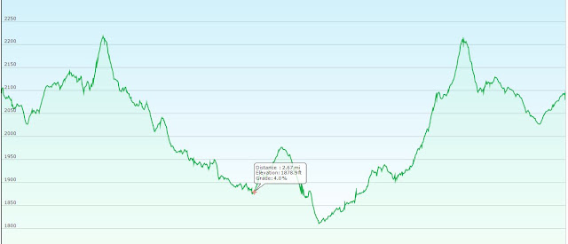
Nancy's GPS Track of Barry's Group - Wishbone Loop, Willow Springs Basin Loop
Mike's Group - 6.5 miles
Directions:
From the Junction of Hunt Highway and Highway 79 N of Florence go north on Hwy 79 for 13 miles to Highway 60. Turn left on Highway 60 and go three miles past King's Ranch. Just past Mountain View Road bear right on E Old West Highway. Turn right onto the first street, South Goldfield Road, and follow it through to the T-intersection with East Lost Dutchman Blvd. and turn left. in 1/2 mile turn right onto North Apache Trail. Proceed to the Museum for a potty stop. Then east about 10 miles on Highway 88 to the trailhead on the left (across from the road from the "25 MPH" sign). 65 miles from Casa Grande.
Google directions to the Museum - Travel 10 miles east. Refer to directions.


No comments:
Post a Comment