Thursday, February 20, 2020

March 13, 14 and 15th, 2020 Chiricahua National Monument

Hiking March 13, 14 and 15, 2020
Overnight Stay in Wilcox, AZ - March 13th and March 14th

Friday – Either Cochise Stronghold, 
Fort Bowie or another hike
Saturday -Hiking in the Chiricahua National Monument 
Sunday – Suggested hike:  The Arch Bridge in the 
National Monument
For convenience for the Hiking Club Activities, it is preferred that we stay in the same hotel. Two years ago we stayed at the Quality Inn, which is now called the Sure Stay Plus Hotel by Best Western. Address - 1100 Rex Allen Drive, Wilcox, AZ. With a Best Western Membership, the rate is about 63.00 (with cancellation flexibility it is 68.00). Without a membership, it is 76.95, and you can cancel.) If I know the numbers of people who plan to go, I may be able to get a group rate, at $63.00 each for 10 rooms. 
Tomorrow at the Picketpost Hike we will have a sign-up sheet to see if we have enough people to reserve 10 rooms. 
You will need to book your own rooms. If we have enough for a discount you can ask to be on the Palm Creek Hiking Group. The hotel phone number is 520-766-3700.   If you want to share a room, please make these arrangements yourself. Please book as soon as possible as availability is tight. 
You will also need to make your own transportation arrangements. 
There will be a sign-up sheet for drivers and passengers tomorrow - please add your information with phone numbers in order to obtain a ride. 

Wednesday, February 19, 2020

February 21, 2020 Picketpost Loop and Arizona Trail to Picketpost Loop - Out and Back.


Picketpost Mountain


Long Group Picketpost Loop - Counterclockwise 9.1 miles. John R. lead this group of 18 hikers. 


The light aqua colour at the bottom shows the Arizona Trail where the medium hikers went in relation to the Picketpost Loop. 


Medium Hike - Arizona trail to the Picketpost Loop - Out and Back. 7.1 miles


Picketpost - Arizona Trail - out and back

Remember to bring lunch and lots of water, the weather is hot.
We need Drivers for both hikes.

Driving Distance, Time and Directions to Picket Post Trailhead 
Go right at the park exit and north on Henness Road 0.7 miles to Cottonwood.
Turn right and go east 2.8 miles to N Overfield Road. Turn left and go north 3.9 miles to
Woodruff Road. Go right and east 1.9 miles to Signal Peak road, turn left and go north 2.9 miles to Hunt Highway. Turn right and go east 6 miles to SR79 at the dead end. Turn left and go north on highway SR79 for 12.7 miles to Highway 60. Go right on Highway 60 for 9 miles and turn right at the Picketpost Trailhead sign onto a dirt road. Drive 0.4 miles to a dead-end and Picketpost Trailhead sign. Turn left and proceed for 0.6 miles. The road turns right into the parking area. It is 55 miles and takes 1:05 minutes to drive. There are pit toilets.

Google Maps to Picketpost Trailhead

Casa Grande Mountain Hike
Casa Grande Mountain Hike leaves the Palm Creek Parking Lot at 8:00 and arrives back to the Park before lunch. Bring lots of water as it may be a hot day.

Proposed next hikes- Schedule may change.

Feb 28 - Bear Canyon to Seven Falls - Sabino Canyon - We will check out the ticket situation for the smaller, shorter tram for the medium hikers. 
March 6 - American Flag Trail near Oracle
March 13 -14 - Weekend Chiricahua hikes.
Nancy’s cell: 403-896-9899 
Note: These hikes are designed to be an outing, not a race. Hikers are encouraged to hike together, socialize, and enjoy the fresh air and exercise, stopping as necessary to rest. To assure all hikers are accounted for, drivers will make sure that all the same hikers they take return with them.

Monday, February 10, 2020

February 14, 2020 Miner's Needle/Coffee Flat Trail


This hike was divided up into two groups. 
Jerry lead the medium hike of about 18 hikers on Miner's needle trail. Distance 7 miles.


This picture was taken from the Miner's summit and Bluff Springs Trail 


John lead the long hike on Coffee Flats trail with 5 hikers at a distance of 11.8 miles.


The Miner's Needle Hike and Coffee Flat Trail both start at Dutchman's #104 and lead steadily upward past scenery of various volcanic rock formations and vistas until it meets Coffee Flat Trail #108.  The trail to a view of Miner's needle keeps going to the left on Dutchman #104 (medium hike). The Coffee Flat Trail turns right (long hike). Depending on arrangements, the medium hike may take Coffee Flat instead of Miner's needle. They are both out and back. 


Directions to Peralta Trailhead
From Palm Creek go right out of the park gate to Cottonwood, turn right. Drive 2.7 miles then turn left on Overfield Road and drive 4 miles to Woodruff Road and turn right. Drive 2 miles then turn left onto N Signal Peak Road. Drive 3.6 miles to Highway 87 which turns into 287 for another 8 miles. Turn left at the lights to Attaway Road and drive for 3 miles, then turn right onto W Hunt Highway. Drive 5.6 miles to Highway 79. Turn left on Highway 79 and drive 14 miles to the junction of Highway 60. Turn left (west) onto Highway 60. After about 8 miles turn right at the traffic light on East Peralta Road. Proceed through the residential area and past the school and onto gravel to Peralta Trailhead (about 7 miles). The driving distance is 62 miles.

Tuesday, January 28, 2020

Important information for this hike Palm Creek Hiking Club Friday, February 7, 2020

Important information for this hike

Palm Creek Hiking Club

Friday, February 7, 2020


As noted in the first handout for this hike there is a Tram (now called Crawler) for this hike.
To assure places on the Crawler you need to buy your ticket online. There are only 56
spaces available so it is important to purchase the $12.00 ticket as soon as possible.
Each hiker has this responsibility. The website is www.sabinocanyoncrawler.com. When
purchasing the ticket you will need to select the 10:00 AM Sabino Canyon Tour. 


To make sure we don’t miss the Crawler we need to:
  1. Leave Palm Creek parking lot at 8:00 sharp. 
  2. Make sure a member in your car has an America the Beautiful Senior’s pass for National Parks. Go to the left-hand side at the gate if you have a pass. If you do not have a pass you pay $5.00 per car and you may have to wait longer. 
  3. We all need to be at the Crawler departure site location at least 15 minutes before departure (9:45).
  4. Make sure you waste no time as you gather equipment and use the washrooms.  
The Crawler goes to “stops” along the way where people can get off when they choose. We will be riding to the end, which is stop 9. The Crawler’s last pick up at #9 is 4:30. We need to be back in time. We will gauge our hike accordingly. 
Please don’t be deterred by these arrangements. We want this beautiful hike to be successful.  


February 7, 2020 Hutch's Pool - Sabino Canyon


This hike located in the beautiful mountains of Sabino Canyon starts at the end of #9
Tram stop. The beginning of the trail has switchbacks that lead to a Junction of Phoneline Trail. The Hutch's pool trail turns left and up another set of switchbacks. At the top, there are views of Sabino Canyon. The trail then winds around to the other side of the mountain where parts of Mount Lemmon can be seen. From here it winds down into a valley and levels out across meadows. The fork in the trail is a good place to stop for lunch for the medium group. (6 miles total). The long hike will continue to Hutch's pool (8.9 miles total). We need to keep in mind that the tram's last ride is 4:30. 
Directions to the Trailhead: 
From the Palm Creek Park's Main gate and turn left on Henness Road to Florence Blvd. Drive to 1-10 and turn south toward Tucson. Drive 53 miles to Exit 248 toward Ina Road. Turn left onto Ina Road and drive east (7.1 miles) until the highway meets Skyline Drive and starts heading southeast. After 1.9 miles this road turns into Sunrise Drive. In 6.3 miles turn left at the light onto Sabino Canyon Road. Sabino Canyon Visitor Center is a short distance on the right. It is 70.2 miles from Palm Creek to the Visitor Center. You can use your America the Beautiful Pass for your car (otherwise the fee is $5.00 per car). At the Visitor Center proceed to the Tram where you can purchase a ticket (cost $10.00 per person). Try to embark on the Tram as a group. 

https://www.alltrails.com/explore/trail/us/arizona/hutchs-pool - this hike has not taken off the mileage
for the 3.8-mile tram ride to the trailhead.

Casa Grande Mountain Hike

Casa Grande Mountain Hike leaves the Palm Creek Parking Lot at 8:00 and arrives back
to the park before lunch.

 Proposed Next Hikes - Schedule may change
February 14 - Miner's Needle or Coffee Flat - Out and Back - Medium Group Coffee Flat - Out and Back - Long Hike
February 21 - Picketpost Mountain - South Trail - Medium Group
Picketpost Mountain Loop - Long Hike - Counterclockwise.
February 28 Bear Canyon to Seven Falls - Sabino Canyon - Out and Back for both groups.


Nancy's Cell - 403-896-9899


Note: These hikes are designed to be an outing, not a race. Hikers are encouraged to hike together, socialize, and enjoy the fresh air and exercise, stopping as necessary to rest. To assure all hikers are accounted for, drivers will make sure that all the same hikers they take, return with them. 

Monday, January 27, 2020

January 31, 2020 Hidden Valley (Fat Man's Pass) - South Mountain


 Jerry's group for Medium Hike - Buena Vista parking lot


Dobbin's Lookout


The Medium Hike starts at Summit Road for a 7.5 mile hike Hidden Valley, commonly known as Fat

Man’s Pass. This hike is fun, hiking over and under great boulders. 
The Long Hike also goes to Hidden Valley, but it takes hiking trails up a ridge that overlooks the
Airport and the City of Phoenix. The rock formations are unique to the area. 
Directions: 
Summit Road - Medium Hike - Take 1-10 north to exit 155 (33 miles). In 0.9 miles turn left on
Baseline Road. Follow Baseline for 4.7 miles then turn left onto S. 7th St. In one mile turn right
onto East Dobbins Road for 0.4 miles Then turn left onto S. Central Ave. and drive for 1 mile. 
There is a Ranger Station and Washroom facilities here. Proceed on S. Central Ave for another
1.6 miles and wind up the road, turn left onto Summit Road and wind further for 3.7 miles to Dobbins
Lookout to the parking area. There are also washroom facilities at the Dobbin's Lookout.
51 miles driving distance. 


Pima Canyon Trailhead - Long Hike - Take 1-10 North for 31 miles to exit 157 to Elliott Road.
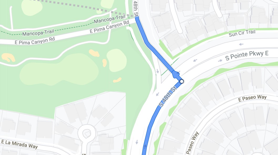
Turn Left on Elliott Road for 1.1 miles then turn right onto S. 48th St. keep following S. 48 St.
as it turns left at a left-hand turn lane. 


(If you do not turn left and follow what looks like 48th street to the right you will end up on
St. Point Parkway E.- don’t go here. If you miss this turn and are on St. Point Parkway -
keep following it until you see 48th st. where you can turn left and loop back on 48th and
to the Pima Canyon Trailhead.)  Then turn an immediate left to Pima Canyon Road.
Follow this road to the trailhead. There are pit toilets and a large parking area. 42 miles
driving distance. B- hike. 7 - 8 miles. 

Casa Grande Mountain Hike

Casa Grande Mountain Hike leaves the Palm Creek Parking Lot at 8:00 and arrives back to the
Park before lunch. 

Proposed next hikes- Schedule may change

February 7 - Hutch’s Pool - Sabino Canyon - Out and back - There is a tram ride and fee. 
February 14 - Medium Hike - Miner’s Needle out and back
                      Long Hike - Coffee Flat - Out and Back
February 21 - Picketpost Mountain - South Trail - Medium Group. 
              Picketpost Mountain - Long hike - Picketpost Mountain Loop - Counterclockwise 


Nancy’s cell: 403-896-9899   
Note: These hikes are designed to be an outing, not a race. Hikers are encouraged to hike
together, socialize, and enjoy the fresh air and exercise, stopping as necessary to rest. To
assure all hikers are accounted for, drivers will make sure that all the same hikers they take
return with them.
Please read our Blogspot: www.palmcreekhikers3.blogspot.com

Tuesday, January 21, 2020

January 24, 2020 Casa Grande Mountain. Hike to the Flag

Medium Hike - Leaders John and Montey. This hike started in Hanna Trailhead and went up the concrete road to the Radio Tower. From there it winds up through a trail of rock until you come up to a great view of Casa Grande and surrounding area and of course the Flag. 

Jerry's Pictures


Montey's Picture of the Flag from below


"Welcome Back" is this Friday at 11:00 in Palm Park. In order not to conflict with this event the hike will be at Casa Grande Mountain. It is a short hike and hopefully, we will be back before noon. 

There will be two Casa Grande Hikes: 
Short Hike at Casa Grande Mountain - Usual hike
Medium Hike at Casa Grande Mountain to the Flag 

Google Maps to Peart Road Trailhead  But we may be using another trailhead, like Hanna Trailhead. Stay tuned.